


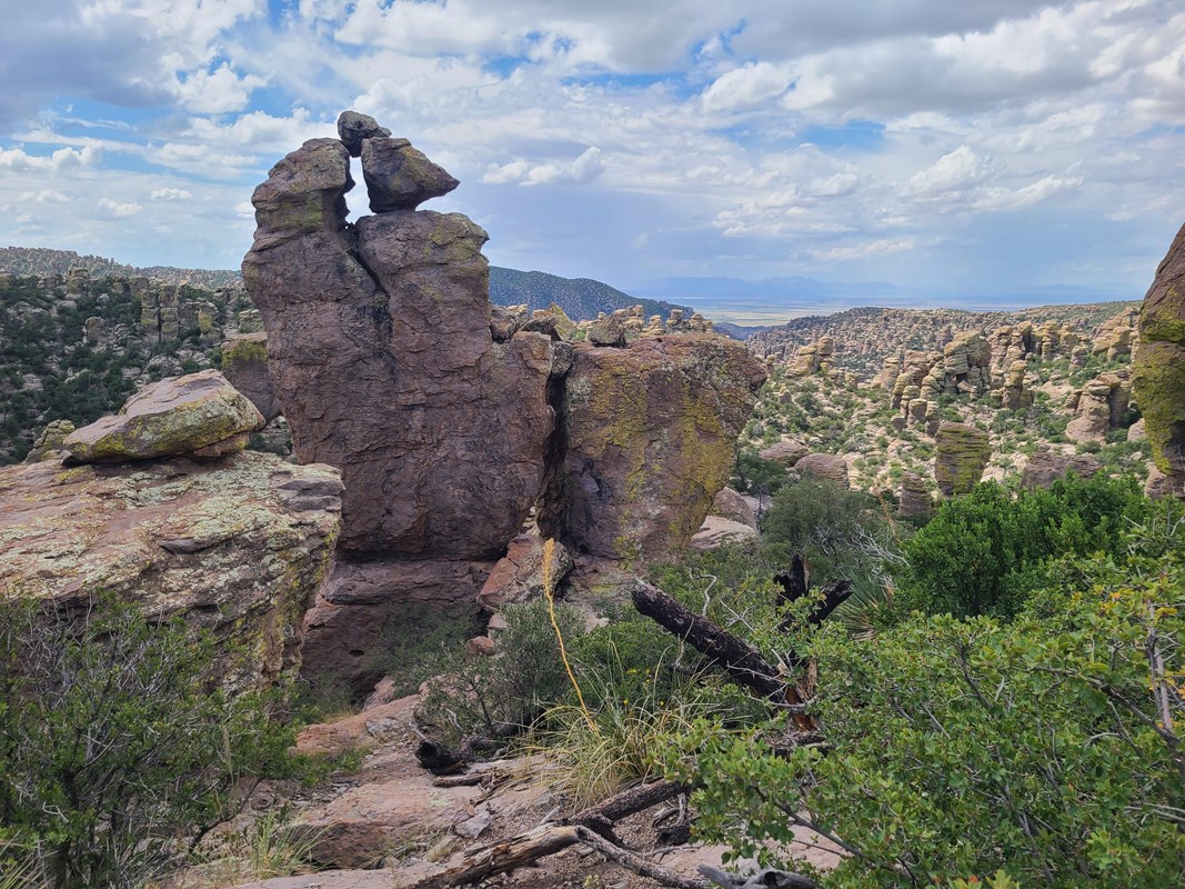
There is a remarkable new answer to the question, “What makes living in Southern Arizona special?” On October 20, 2026, Chiricahua National Monument officially became Chiricahua National Park, the United States’ 64th national park and its newest. For Cochise County residents, the landscape itself is familiar: stone spires, balanced boulders, oak-lined canyons, and a night sky that makes you remember how many stars there are. What changed is the national recognition.
The announcement is exciting, but Chiricahua is much more than a headline. It is a place to bring visiting family, introduce children to hiking, spend an unhurried afternoon watching birds, or explore a story that reaches far deeper than the arrival of modern tourism. Here is our local-minded guide to seeing the park, understanding its history, and discovering the other protected landscapes that make this corner of Arizona so special.
First, what changed on October 20?
According to the National Park Service announcement dated October 20, 2026, the Chiricahua National Park Act redesignated the former national monument as a national park. It was originally established as a national monument on April 18, 1924, and its approximately 12,000 acres have been protected for more than a century.
Importantly, this is not a brand-new park carved out of previously unprotected land. The NPS says its boundaries have not expanded, and the designation itself does not add new facilities, change existing visitor fees, or guarantee additional funding. Its hiking trails, scenic road, campground, and historic sites continue to welcome visitors. Some older signs and online pages may still say “National Monument” while the agency updates them. The name has changed; the reasons to visit have been here all along.
Why the rocks look as though they belong on another planet
Chiricahua’s nickname, the “Wonderland of Rocks,” is earned. About 27 million years ago, an enormous volcanic eruption blanketed the region with ash and other material. Over immense stretches of time, the hardened volcanic rock fractured and eroded into the columns, pinnacles, and gravity-defying formations we see today. The landscape is a vivid geology lesson you can walk through, not just read about.
The park sits within the Chiricahua Mountains, one of southeastern Arizona’s celebrated “sky islands.” Here, higher, cooler mountains rise above surrounding desert and grassland, creating habitat for an extraordinary mix of plants and animals. The transitions are part of the magic: drive from an open valley into woodland, then emerge among rock towers and expansive mountain views.
The best first visit: take the scenic drive to Massai Point
If you have just a few hours, make the eight-mile paved scenic drive the backbone of your trip. It winds upward past dramatic geology and several pullouts, ending at Massai Point, where the formations spread across the landscape in every direction. The overlook, interpretive exhibits, picnic area, and short nature trail make this a memorable introduction even if a long hike is not on the agenda.
Start at the visitor center for a map and current trail advice. Then follow the road uphill, stopping at viewpoints when safe and leaving time to linger at the top. The Massai Point Nature Trail is a roughly half-mile loop; part of the area near the parking lot is more accessible than the full loop, which includes uneven surfaces and steps. For the park’s most accessible paved walk, the NPS identifies the short Bonita Creek Loop in the lower canyon.
Vehicle note: The upper scenic road is narrow and winding. The NPS limits vehicles beyond the campground to 24 feet and does not allow trailers on the scenic drive. Larger vehicles and trailers have additional restrictions at Faraway Ranch. Check the official scenic-drive guidance before bringing an RV.
Pick the Chiricahua hike that fits your day
One of the park’s strengths is that you do not have to be a seasoned backpacker to feel immersed in the rocks. There are rewarding options at several effort levels, and it is perfectly fine to let the scenery set the pace.
For an easygoing walk
Bonita Creek Trail offers a gentler way to look for birds and wildlife near the canyon floor. Silver Spur Meadow Trail, a leisurely walk through the Faraway Ranch area, adds human history to the experience. Both are among the park’s limited dog-friendly walking options when pets are leashed. For a brief taste of the upper rock formations, the Massai Point Nature Trail is a favorite, though the entire loop is not wheelchair accessible.
For a memorable moderate adventure
The Echo Canyon Grottoes are about a half-mile from the Echo Canyon parking area, reached along a rocky trail with elevation change. It is an excellent shorter outing if you want to get among the formations. Those ready for more can take the Echo Canyon Loop, approximately 3.3 miles through grottoes, narrow passages, sweeping viewpoints, and some steep, uneven terrain. Allow several hours to enjoy it rather than racing the clock.
For strong hikers who want the full experience
The Heart of Rocks route is a strenuous outing of roughly 7.3 miles round-trip from common starting points, with substantial climbing and rocky steps. Its reward is an intimate view of formations such as Big Balanced Rock. The longer Big Loop links many of the park’s signature trails and deserves an early start, plenty of water, and realistic attention to fitness and conditions.
Use the current NPS hiking guide for maps and route descriptions. The park’s shuttle is not a dependable transportation plan: NPS information indicates service has been suspended and any future transport depends on staffing and conditions. Arrange your own return if you choose a one-way route. Pets are prohibited on most upper trails, and bicycles and e-bikes are not allowed on park trails.
Faraway Ranch: the human story behind the scenery
It is easy to arrive for the geology and discover that the history stays with you just as strongly. Long before the park was established, this was part of the homeland of the Chiricahua Apache, and the NPS recognizes deep and continuing connections between the landscape and numerous tribal nations. That history should be understood as more than a preface to the story of settlers and tourists.
The Faraway Ranch Historic District also tells an important chapter of the region’s later history. Swedish immigrants Neil and Emma Erickson established their homestead in the 1880s. Their daughter Lillian and her husband Ed Riggs later helped turn it into a guest ranch, sharing the beauty of the surrounding formations with visitors. Their efforts, along with others, helped build support for federal protection in 1924. Ed Riggs also played a role in developing trails, including work with the Civilian Conservation Corps.
Today, you can explore the historic district and walk its grounds. Do not assume interior house tours are offered on a particular day; check ranger-program information at the visitor center before counting on one. The NPS Faraway Ranch history page is an excellent place to begin.
Birding, wildlife, and one of the region’s great night skies
Bring binoculars even if you do not consider yourself a birder. The Chiricahua sky-island setting supports an unusual mix of species, and the NPS highlights the Bonita Creek area as a particularly good place to watch for birds. Quiet visitors may also encounter deer, coatimundis, javelinas, or other wildlife. Observe from a distance, never feed animals, and give everything from snakes to mammals room to move. The park’s current conditions page includes a rabies warning for southeastern Arizona, another good reason not to approach wildlife.
Then there is the sky. Chiricahua was recognized as an International Dark Sky Park in 2021, and the redesignation does not change that commitment. After sunset, the landscape becomes an entirely different kind of destination. If you stay to watch the stars, bring warm layers, a red-light flashlight, and an awareness that trails and roads can be dark and remote. Stargazing is a wonderful reason to return, but it is not a reason to underestimate nighttime terrain.
Before you go: practical details that matter
As of October 23, 2026, the NPS lists no entrance or parking fee at Chiricahua. The park road and grounds are generally open 24 hours a day, while the visitor center is typically open 8:30 a.m.–4:30 p.m. Bonita Canyon Campground is reservation-based and has its own fees. These details may change, so use the fees page and current alerts and conditions when planning.
For the paved approach from Willcox, the NPS directs visitors to Arizona Highway 186 and then Highway 181; another paved approach comes from the south through Sunizona. The park has one main entrance, and the scenic road ends at Massai Point rather than crossing the mountain range. Download maps in advance because cellular reception is unreliable. Fuel up and pack water and food before leaving the larger communities; supplies are limited near the entrance.
Autumn is inviting, but higher elevations can bring wind and chilly evenings. Winter may bring snow or ice, and summer monsoon storms can create dangerous runoff and road conditions. On our October 23 review, the NPS conditions page did not list a park-wide closure, but road restrictions, weather, and individual facilities should always be rechecked before departure. For current information, call the visitor center at (520) 824-3560.
Beyond Chiricahua: a whole region of protected wonders
One national park is worth celebrating. What makes southeastern Arizona especially compelling is that it is part of a larger collection of remarkable places, each with its own history, geology, management, and kind of adventure. These are separate destinations, not additional sections of Chiricahua National Park.
Montezuma Pass and Coronado National Memorial: big views, layered history
Closer to Sierra Vista and Hereford, Coronado National Memorial preserves a landscape where visitors can consider the profound, often painful consequences of the sixteenth-century Coronado expedition and the long histories of the borderlands. The visitor center provides context, while the road to Montezuma Pass climbs to an overlook at about 6,575 feet, with views toward the San Pedro Valley, San Rafael Valley, and Mexico.
The overlook is generally accessible from dawn to dusk, but the final two miles of the three-mile road west of the visitor center are graded dirt, with a 24-foot vehicle-length limit. Heavy rain or snow can close the road temporarily. It is a scenic drive to approach thoughtfully, not one to rush in an oversized vehicle. Confirm road conditions through the NPS access information or call (520) 366-5515.
Coronado Cave: a different kind of adventure
Also within Coronado National Memorial, Coronado Cave offers a rugged, undeveloped caving experience. Unlike a guided show cave, this one requires a half-mile uphill hike gaining approximately 500 feet, followed by a scramble over slick rock into the cavern. The NPS currently says no permit or reservation is required, but the cave is closed from sunset to sunrise, and pets are not permitted on the cave trail or inside.
Do not confuse “short hike” with “easy outing.” Go with a companion, carry two independent sources of light per person, wear shoes with reliable traction, and turn around if the descent exceeds your comfort level. Check in at the visitor center for safety and preservation guidance. See the official Coronado Cave visitor instructions before attempting the trip.
Kartchner Caverns State Park: a living cave near Benson
For an entirely different underground experience, Kartchner Caverns State Park protects an extraordinary living limestone cave discovered by Gary Tenen and Randy Tufts in 1974. Its delicate formations are still growing, and the guided-tour system is designed to protect that fragile environment.
Plan ahead and reserve a cave tour rather than assuming walk-in availability. Arizona State Parks offers tour options such as the Rotunda/Throne Room experience, while Big Room access is seasonal to protect a maternity colony of bats. Tour availability, prices, and operating rules vary. The Discovery Center is generally listed as open 8 a.m.–5 p.m.; standard day-use entrance fees apply to visitors without qualifying cave-tour or camping reservations, and cave tours carry separate ticket prices. Cameras, cell phones, bags, and food are not allowed inside the cave, so follow the park’s preparation guidance closely. For current availability, use the Arizona State Parks tour-reservation portal.
Why this matters when you call Southern Arizona home
National-park headlines naturally attract travelers. But for people who live in Sierra Vista, Hereford, Benson, Willcox, and the surrounding communities, the deeper benefit is not a one-time vacation. It is the ability to choose a different kind of outdoor day depending on the season and your mood: a family picnic beneath rock spires, a quiet morning with binoculars, a borderlands overlook, a cave tour, or an evening watching the Milky Way.
These places also offer something valuable to newcomers: an introduction to the region that goes beyond a map of neighborhoods. You begin to understand how geology, climate, Indigenous history, ranching, conservation, and small-town life are connected. For more ways to explore, read our guide to fall birding in Sierra Vista or our Bisbee day-trip story.
At The RA Home Team, we believe finding a home also means discovering the place around it. Chiricahua’s new national-park designation gives the rest of the country another reason to look toward Cochise County. Those of us who get to explore Southern Arizona regularly have known for a long time that the real treasure is what waits beyond the front door.
Visitor information checked October 23, 2026. Conditions, reservations, and access can change. Always confirm details with the National Park Service or Arizona State Parks before your trip.